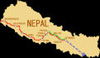
Nepal is located between longitude 80o4' and 88o12' and between latitude 26o22' and 30o27'. It borders the Peoples Republic of China in the north and India in the east, south and west. Nepal has a breadth east to west of 885 km, a mean width of 193 km and covers an area of 147,181 sq km. Topographically the Country is divided into three bands running the full breadth and comprising the Terai (southern plains), the Mid-Hills and the Mountains. The Mid-Hills and Mountains together represent 83% of the total area of Nepal.
The hill areas are geologically very young and active, and are affected by a constant tectonic uplifting accompanied by down-cutting of the river systems. This action on the predominately soft and deeply weathered nature of the rock has produced extremely rugged topography with local differences in elevation varying from 500 meters to 3,500 meters and rising to 8,848 meters (Mount Everest) above mean sea level. The resulting steep, unstable and highly redouble slopes are divided into many gullies and small valleys and the provision and maintenance of even basic infrastructure in such extreme conditions is both difficult and costly.
The Country is administered through five development regions: eastern, central, western, mid-western and far-western. These are further subdivided into 14 zones, 75 districts, 58 municipalities, and 3,914 Village Development Committees. Although the declared policy of Government is to decentralist development responsibility to the local level, this is proving difficult in practice due, in part, to the lack of local capability and hence, poor resource mobilization.
ClimateNepal lies in the monsoon belt but the climate is dictated by altitude and varies from sub-tropical on the Terai plains to alpine and tundra in the Mountains. Annual rainfall differs from place to place ranging from less than 250 mm in the Mountains to more than 4,000 mm in the Mid-Hills (near Pokhara). Most of the precipitation occurs during the period June to September and is concentrated in the Mid-Hills and the Terai. The high concentration during the monsoon months results in flooding, heavy erosion and triggers landslips over a wide area.